Route Map
Southern Thailand Ferry & Bus Route Maps
Planning your journey through Thailand’s southern islands and coastal destinations?
Our route maps give you a clear overview of ferry and combined bus-and-ferry connections across Thailand, from short island crossings to long-distance routes linking the east and west coasts.
Alomst all routes shown on this page operate in both directions and can be searched and booked online via www.phanganferries.com.
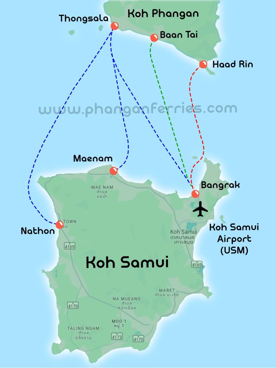
Koh Phangan – Koh Samui Ferry Routes
This map displays all ferry connections between Koh Phangan and Koh Samui, operating in both directions throughout the year.
It is one of the busiest and most important island routes in the Gulf of Thailand.
Daily ferries operate between Thongsala Pier, Baan Tai Pier and Haad Rin Pier on Koh Phangan and Nathon Pier, Bangrak Pier, and Maenam Pier on Koh Samui.
Travel times typically range from 20 to 60 minutes, and fares start from 200 THB depending on the ferry service.
This route is especially popular for:
-
Full Moon Party travel
-
Short island hops
-
Connections via Koh Samui Airport
⇒ Book these routes:
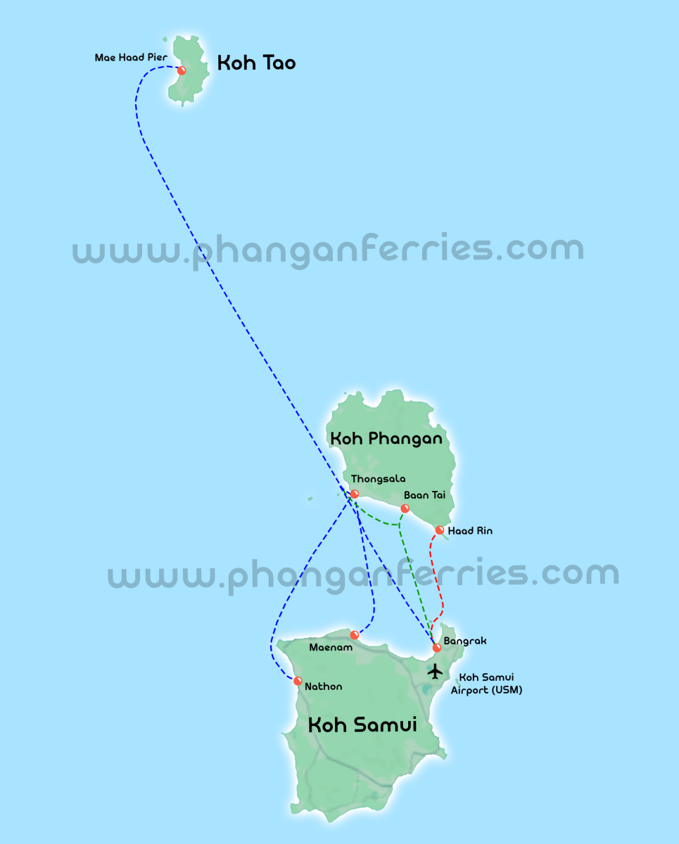
Koh Tao – Koh Phangan – Koh Samui Ferry Routes
This map shows all ferry connections between Koh Tao, Koh Phangan, and Koh Samui, including the main piers on each island.
All routes operate in both directions, with frequent daily departures.
Koh Tao – Koh Phangan Ferry
The route between Mae Haad Pier on Koh Tao and Thongsala Pier on Koh Phangan is one of the most popular island connections in the Gulf of Thailand.
Travel time is approximately 1 to 2 hours, with ticket prices starting from 450 THB.
Multiple ferry operators include Lomprayah, Lomlahkkhirin, Songserm, and Boonsiri, offer daily departures, making this route ideal for flexible island hopping and event travel.
⇒ Popular routes:
Koh Tao – Koh Samui Ferry
The Mae Haad Pier on Koh Tao to Bangrak Pier, Maenam Pier and Nathon Pier on Koh Samui route connects the island to the region’s main transport hub.
Travel time is approximately 1.5 to 2.5 hours, with tickets starting from 550 THB.
Most services include a stopover on Koh Phangan. Major operators include Lomprayah, Lomlahkkhirin, Songserm, and Boonsiri operate this route multiple times per day.
⇒ Popular routes:
Gulf of Thailand & Andaman Ferry Connections
This map shows the Thailand east coast ferry network, focusing on Koh Tao, Koh Phangan, and Koh Samui, and their connections to the mainland — including Surat Thani Airport, Nakhon Si Thammarat Airport, Chumphon Airport, Surat Thani Train Station and Chumphon Train Station — with onward routes to the Andaman Sea.
These transport hubs allow travelers to easily connect between flights, trains, ferries, and buses, making island travel possible from anywhere in Thailand.
All ferry and combined transport routes shown operate in both directions, allowing flexible travel between islands, mainland hubs, and Thailand’s west coast.
From these islands, travelers can connect to and from:
-
Chumphon and Surat Thani
-
Krabi, Phuket, Koh Lanta, and Koh Phi Phi
This network is ideal for travelers combining diving, island events, flights, and east–west island hopping.
⇒ Popular east-coast & cross-coast routes:
.jpg)
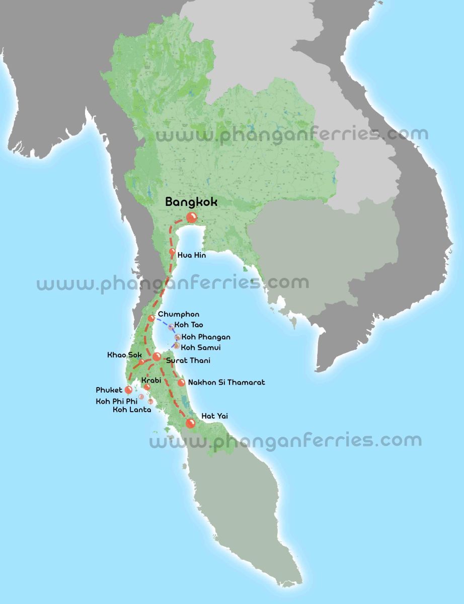
Complete Thailand Ferry & Bus Route Map
This map provides a full overview of our ferry and bus transport network, showing how island destinations connect with the mainland and major cities across the country.
Routes shown are generally available in both northbound and southbound directions, depending on the operator.
Connections extend:
-
From the islands to the mainland
-
Northward to Bangkok
-
Southward to Hat Yai and the Malaysian border
This overview is ideal for travelers planning long-distance or multi-stop journeys across Thailand.
⇒ Long-distance routes: